
Dahab topographic map
Interactive map
Click on the map to display elevation.
About this map
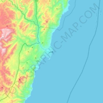
Name: Dahab topographic map, elevation, terrain.
Location: Dahab, South Sinai, 45214, Egypt (28.33636 34.35457 28.65636 34.67457)
Average elevation: 856 ft
Minimum elevation: 0 ft
Maximum elevation: 5,016 ft
Other topographic maps
Click on a map to view its topography, its elevation and its terrain.
Beach of Tropitel Naama Bay + Noria Resort +Amerotel Royal Oasis Resort
Egypt > South Sinai > Sharm El Sheikh
Beach of Tropitel Naama Bay + Noria Resort +Amerotel Royal Oasis Resort, Neema Bay, Naama Bay, Sharm El Sheikh, Ras Umm Sid, South Sinai, Egypt
Average elevation: 62 ft
Gebel Hudera, east
Gebel Hudera, east, South Sinai, Egypt
Average elevation: 2,536 ft
El Tor, Egypt
Egypt > South Sinai > Al Tor
El Tor, Egypt, Al Gabel Street, Al Gabel Village, Al Tor, South Sinai, 46511, Egypt
Average elevation: 26 ft
Sharm El Sheikh
Sharm El Sheikh, Ras Umm Sid, South Sinai, 46619, Egypt
Average elevation: 443 ft
Egupt fjord
Egypt > South Sinai > Taba > Taba Heights
Egupt fjord, Newibaa, Taba Road, Taba City, Taba Heights, Taba, South Sinai, 46621, Egypt
Average elevation: 226 ft