
Council Bluffs topographic map
Interactive map
Click on the map to display elevation.
About this map
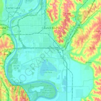
Name: Council Bluffs topographic map, elevation, terrain.
Location: Council Bluffs, Pottawattamie County, Iowa, United States (41.16725 -95.92725 41.29073 -95.75109)
Average elevation: 1,033 ft
Minimum elevation: 955 ft
Maximum elevation: 1,266 ft
Council Bluffs covers a unique topographic region originally composed of prairie and savanna in the Loess Hills with extensive wetlands and deciduous forest along the Missouri River. Excellent vistas can be had from KOIL Point at Fairmont Park, the Lincoln Monument, Kirn Park, and the Lewis and Clark Monument. Lake Manawa State Park is located at the southern edge of the city.
Other topographic maps
Click on a map to view its topography, its elevation and its terrain.
Underwood
United States > Iowa > Pottawattamie County
Underwood, Pottawattamie County, Iowa, United States
Average elevation: 1,109 ft
Crescent
United States > Iowa > Pottawattamie County
Crescent, Pottawattamie County, Iowa, United States
Average elevation: 1,073 ft
Underwood
United States > Iowa > Pottawattamie County > Underwood > Underwood
Underwood, Pottawattamie County, Iowa, 51576, United States
Average elevation: 1,129 ft
Carson
United States > Iowa > Pottawattamie County
Carson, Pottawattamie County, Iowa, 51525, United States
Average elevation: 1,119 ft
Neola
United States > Iowa > Pottawattamie County
Neola, Pottawattamie County, Iowa, United States
Average elevation: 1,125 ft