
Vandalia topographic map
Interactive map
Click on the map to display elevation.
About this map
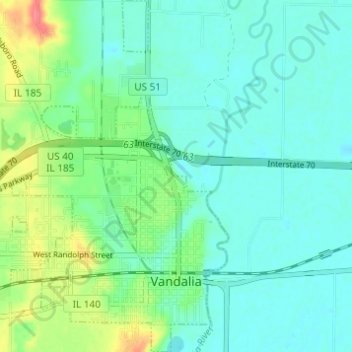
Name: Vandalia topographic map, elevation, terrain.
Location: Vandalia, Fayette County, Illinois, 62471, United States (38.95101 -89.13821 38.99862 -89.08454)
Average elevation: 505 ft
Minimum elevation: 456 ft
Maximum elevation: 650 ft
Other topographic maps
Click on a map to view its topography, its elevation and its terrain.
Carlyle Lake State Wildlife Management Area
United States > Illinois > Fayette County
Carlyle Lake State Wildlife Management Area, Fayette County, Illinois, United States
Average elevation: 443 ft
Avena
United States > Illinois > Fayette County
Avena, Fayette County, Illinois, 62418, United States
Average elevation: 587 ft