
Żydowo topographic map
Interactive map
Click on the map to display elevation.
About this map
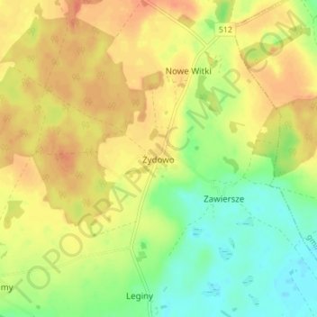
Name: Żydowo topographic map, elevation, terrain.
Average elevation: 262 ft
Minimum elevation: 184 ft
Maximum elevation: 325 ft
Other topographic maps
Click on a map to view its topography, its elevation and its terrain.
Różyna
Poland > Warmian-Masurian Voivodeship > Bartoszyce County
Różyna, gmina Sępopol, Bartoszyce County, Warmian-Masurian Voivodeship, 11-210, Poland
Average elevation: 135 ft
Żuławy
Poland > Warmian-Masurian Voivodeship > Bartoszyce County
Żuławy, gmina Górowo Iławeckie, Bartoszyce County, Warmian-Masurian Voivodeship, Poland
Average elevation: 262 ft