
Frasnes-lez-Anvaing topographic map
Interactive map
Click on the map to display elevation.
About this map
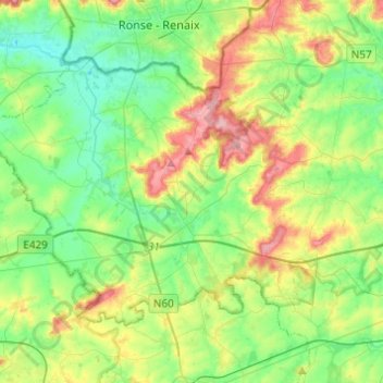
Name: Frasnes-lez-Anvaing topographic map, elevation, terrain.
Location: Frasnes-lez-Anvaing, Ath, Hainaut, Wallonia, Belgium (50.62591 3.48732 50.73473 3.73140)
Average elevation: 184 ft
Minimum elevation: 39 ft
Maximum elevation: 476 ft
Other topographic maps
Click on a map to view its topography, its elevation and its terrain.
Tongre-Notre-Dame
Tongre-Notre-Dame, Chièvres, Ath, Hainaut, Wallonia, 7951, Belgium
Average elevation: 184 ft
Ellezelles
Ellezelles, Ath, Hainaut, Wallonia, Belgium
Average elevation: 243 ft