
Rodney topographic map
Interactive map
Click on the map to display elevation.
About this map
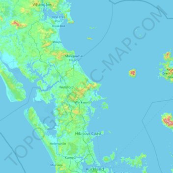
Name: Rodney topographic map, elevation, terrain.
Location: Rodney, Auckland, New Zealand (-36.87945 173.89633 -35.69839 175.26568)
Average elevation: 89 ft
Minimum elevation: -3 ft
Maximum elevation: 2,792 ft
Other topographic maps
Click on a map to view its topography, its elevation and its terrain.
Omaha Beach
New Zealand > Auckland > Rodney > Omaha
Omaha Beach, Omaha, Rodney, Auckland, New Zealand
Average elevation: 10 ft
Takangaroa Island
New Zealand > Auckland > Rodney
Takangaroa Island, Rodney, Auckland, New Zealand
Average elevation: 0 ft