
Terek River topographic map
Interactive map
Click on the map to display elevation.
About this map
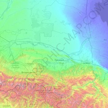
Name: Terek River topographic map, elevation, terrain.
Average elevation: 2,329 ft
Minimum elevation: -102 ft
Maximum elevation: 16,158 ft
Other topographic maps
Click on a map to view its topography, its elevation and its terrain.
Ushkaloy
Russia > Chechen Republic > Ushkaloy
Ushkaloy, Itum-Kalinsky District, Chechen Republic, North Caucasus federal district, Russia
Average elevation: 3,031 ft
Argun
Russia > Chechen Republic > городской округ Аргун > Argun
Argun, городской округ Аргун, Chechen Republic, North Caucasian Federal District, Russia
Average elevation: 387 ft