
Kelantan topographic map
Interactive map
Click on the map to display elevation.
About this map
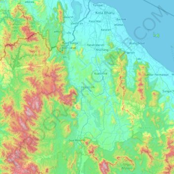
Name: Kelantan topographic map, elevation, terrain.
Location: Kelantan, Malásia (4.54631 101.33291 6.24734 102.66649)
Average elevation: 1,178 ft
Minimum elevation: -3 ft
Maximum elevation: 7,044 ft
Other topographic maps
Click on a map to view its topography, its elevation and its terrain.
Medan Ilmu
Malásia > Kelantan > Medan Ilmu
Medan Ilmu, Kota Bharu, Kelantan, 15000, Malásia
Average elevation: 20 ft