
Jollyville Plateau topographic map
Interactive map
Click on the map to display elevation.
About this map
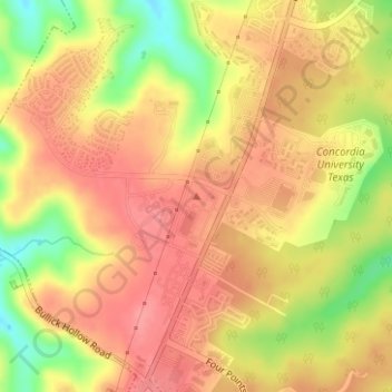
Name: Jollyville Plateau topographic map, elevation, terrain.
Location: Jollyville Plateau, Austin, Travis County, Texas, 78726, USA (30.41654 -97.85004 30.41664 -97.84994)
Average elevation: 974 ft
Minimum elevation: 807 ft
Maximum elevation: 1,063 ft
Other topographic maps
Click on a map to view its topography, its elevation and its terrain.
Stephenson Nature Preserve And Outdoor Education Center
Stephenson Nature Preserve And Outdoor Education Center, West William Cannon Drive, Whispering Oaks, Austin, Travis County, Texas, 78749, USA
Average elevation: 755 ft
Balcones District Park
Balcones District Park, 12017, North Loop Business Park, Austin, Travis County, Texas, 78759, USA
Average elevation: 771 ft
Red Bud Isle
Red Bud Isle, Austin, Travis County, Texas, USA
Average elevation: 594 ft