
Erdenetsagaan topographic map
Interactive map
Click on the map to display elevation.
About this map
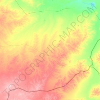
Name: Erdenetsagaan topographic map, elevation, terrain.
Location: Erdenetsagaan, Sükhbaatar, Mongolia (45.37605 114.46292 46.59167 116.57760)
Average elevation: 3,363 ft
Minimum elevation: 2,215 ft
Maximum elevation: 5,509 ft
Other topographic maps
Click on a map to view its topography, its elevation and its terrain.
Erdenetsagaan
Mongolia > Sükhbaatar > Erdenetsagaan
Erdenetsagaan, Sükhbaatar, Mongolia
Average elevation: 3,533 ft