
Molenbeek-Wersbeek topographic map
Interactive map
Click on the map to display elevation.
About this map
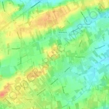
Name: Molenbeek-Wersbeek topographic map, elevation, terrain.
Average elevation: 200 ft
Minimum elevation: 128 ft
Maximum elevation: 282 ft
Other topographic maps
Click on a map to view its topography, its elevation and its terrain.
Bekkevoort
België > Vlaams-Brabant > Leuven > Bekkevoort
Bekkevoort, Leuven, Vlaams-Brabant, 3460, België
Average elevation: 174 ft