
Camden topographic map
Interactive map
Click on the map to display elevation.
About this map
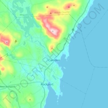
Name: Camden topographic map, elevation, terrain.
Location: Camden, Knox County, Maine, 04843, United States (44.17420 -69.16544 44.25946 -69.00469)
Average elevation: 207 ft
Minimum elevation: -7 ft
Maximum elevation: 1,345 ft
According to the U.S. Census Bureau, the town has a total area of 26.65 square miles (69.02 km2), of which, 18.24 square miles (47.24 km2) of it is land and 8.41 square miles (21.78 km2) is water. Drained by the Megunticook River, Camden is located beside Penobscot Bay and the Gulf of Maine, part of the Atlantic Ocean. Principal bodies of water include: Megunticook Lake, Hosmer Pond (54 acres), Impoundment (Seabright Pond) (74 acres) and Lily Pond (32 acres). Mount Megunticook has an elevation of 1385 feet (419 m).
Other topographic maps
Click on a map to view its topography, its elevation and its terrain.
Warren
United States > Maine > Knox County
Warren, Knox County, Maine, 04864, United States
Average elevation: 154 ft
Matinicus Island
United States > Maine > Knox County > Matinicus Isle Plantation
Matinicus Island, Matinicus Isle Plantation, Knox County, Maine, United States
Average elevation: 16 ft
Rockport
United States > Maine > Knox County
Rockport, Knox County, Maine, United States
Average elevation: 135 ft
South Thomaston
United States > Maine > Knox County > South Thomaston
South Thomaston, Knox County, Maine, 04858, United States
Average elevation: 33 ft
Saint George
United States > Maine > Knox County
Saint George, Knox County, Maine, United States
Average elevation: 10 ft
Hope
United States > Maine > Knox County
Hope, Knox County, Maine, 04847, United States
Average elevation: 390 ft
Appleton
United States > Maine > Knox County
Appleton, Knox County, Maine, United States
Average elevation: 344 ft
Friendship
United States > Maine > Knox County
Friendship, Knox County, Maine, 04547, United States
Average elevation: 33 ft
Union
United States > Maine > Knox County
Union, Knox County, Maine, 04862, United States
Average elevation: 292 ft
Matinicus Isle Plantation
United States > Maine > Knox County
Matinicus Isle Plantation, Knox County, Maine, 04851, United States
Average elevation: 0 ft
Owls Head
United States > Maine > Knox County
Owls Head, Knox County, Maine, 04854, United States
Average elevation: 13 ft
Vinalhaven
United States > Maine > Knox County
Vinalhaven, Knox County, Maine, 04863, United States
Average elevation: 7 ft
Penobscot Bay
United States > Maine > Knox County > North Haven
Penobscot Bay, North Haven, Knox County, Maine, United States
Average elevation: 0 ft
Rockland
United States > Maine > Knox County
Rockland, Knox County, Maine, 04841, United States
Average elevation: 121 ft