
Alleyton topographic map
Interactive map
Click on the map to display elevation.
About this map
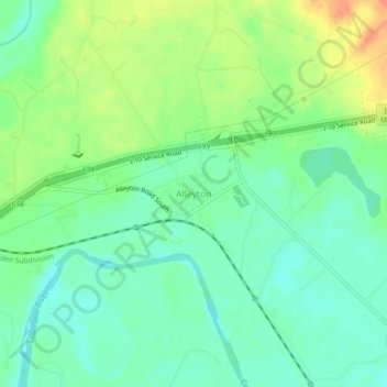
Name: Alleyton topographic map, elevation, terrain.
Location: Alleyton, Colorado County, Texas, 78935, United States (29.68829 -96.50702 29.72829 -96.46702)
Average elevation: 203 ft
Minimum elevation: 151 ft
Maximum elevation: 289 ft
Alleyton is located about 405 meters north of the Colorado River at its closest point. It is 3 miles (5 km) east of Columbus on south Interstate 10. It is bounded on the north by I-10, the south and west by Alleyton Road, and the east by FM-102.[1] Alleyton's elevation stays at approximately 57 meters with a seven-meter decline to the river.
Other topographic maps
Click on a map to view its topography, its elevation and its terrain.
Eagle Lake
United States > Texas > Colorado County
Eagle Lake, Colorado County, Texas, 77434, United States
Average elevation: 177 ft
Columbus
United States > Texas > Colorado County
Columbus, Colorado County, Texas, 78934, United States
Average elevation: 200 ft
Weimar
United States > Texas > Colorado County
Weimar, Colorado County, Texas, 78962, United States
Average elevation: 390 ft
Sheridan
United States > Texas > Colorado County
Sheridan, Colorado County, Texas, 77475, United States
Average elevation: 269 ft
Glidden
United States > Texas > Colorado County
Glidden, Colorado County, Texas, 78943, United States
Average elevation: 243 ft