
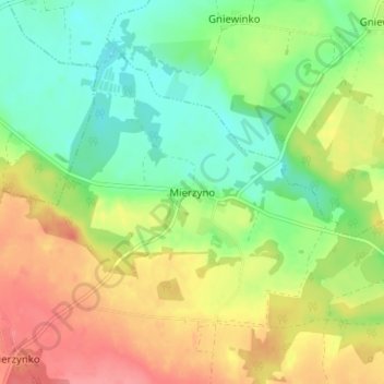
Mierzyno topographic map
Interactive map
Click on the map to display elevation.
About this map
Name: Mierzyno topographic map, elevation, terrain.
Average elevation: 230 ft
Minimum elevation: 118 ft
Maximum elevation: 371 ft
Other topographic maps
Click on a map to view its topography, its elevation and its terrain.
Jezioro Żarnowieckie
Poland > Pomeranian Voivodeship > Wejherowo County > Czymanowo
Jezioro Żarnowieckie, Czymanowo, gmina Gniewino, Wejherowo County, Pomeranian Voivodeship, 84-250, Poland
Average elevation: 121 ft
Łęczyce
Poland > Pomeranian Voivodeship > Wejherowo County
Łęczyce, gmina Łęczyce, Wejherowo County, Pomeranian Voivodeship, Poland
Average elevation: 171 ft
Choczewo
Poland > Pomeranian Voivodeship > Wejherowo County
Choczewo, gmina Choczewo, Wejherowo County, Pomeranian Voivodeship, 84-210, Poland
Average elevation: 220 ft
Rumia
Poland > Pomeranian Voivodeship > Wejherowo County > Rumia
Rumia, Wejherowo County, Pomeranian Voivodeship, 84-230, Poland
Average elevation: 226 ft
Szemud
Poland > Pomeranian Voivodeship > Wejherowo County > Szemud
Szemud, gmina Szemud, Wejherowo County, Pomeranian Voivodeship, Poland
Average elevation: 610 ft
Reda
Poland > Pomeranian Voivodeship > Wejherowo County > Reda
Reda, Wejherowo County, Pomeranian Voivodeship, 84-240, Poland
Average elevation: 187 ft
Wejherowo
Poland > Pomeranian Voivodeship > Wejherowo County > Wejherowo
Wejherowo, Wejherowo County, Pomeranian Voivodeship, Poland
Average elevation: 233 ft