
Crescent Springs topographic map
Interactive map
Click on the map to display elevation.
About this map
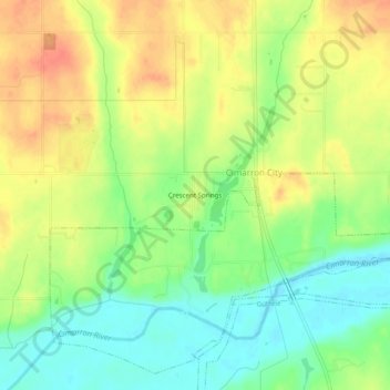
Name: Crescent Springs topographic map, elevation, terrain.
Average elevation: 1,007 ft
Minimum elevation: 932 ft
Maximum elevation: 1,083 ft
Other topographic maps
Click on a map to view its topography, its elevation and its terrain.
Langston
United States > Oklahoma > Logan County
Langston, Logan County, Oklahoma, United States
Average elevation: 968 ft
Meridian
United States > Oklahoma > Logan County
Meridian, Logan County, Oklahoma, United States
Average elevation: 1,017 ft
Guthrie
United States > Oklahoma > Logan County
Guthrie, Logan County, Oklahoma, 73044, United States
Average elevation: 1,083 ft
Iconium
United States > Oklahoma > Logan County
Iconium, Logan County, Oklahoma, United States
Average elevation: 1,073 ft
Coyle
United States > Oklahoma > Logan County
Coyle, Logan County, Oklahoma, United States
Average elevation: 896 ft