
Parc de Wolvendael topographic map
Interactive map
Click on the map to display elevation.
About this map
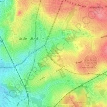
Name: Parc de Wolvendael topographic map, elevation, terrain.
Location: Parc de Wolvendael, Uccle, Bruxelles-Capitale, 1180, Belgique (50.79637 4.34169 50.80315 4.34899)
Average elevation: 236 ft
Minimum elevation: 95 ft
Maximum elevation: 377 ft
Other topographic maps
Click on a map to view its topography, its elevation and its terrain.
Bois de la Cambre
Belgique > Bruxelles-Capitale > Ville de Bruxelles > Uccle
Bois de la Cambre, La Cambre, Bruxelles, Ville de Bruxelles, Bruxelles-Capitale, 1000, Belgique
Average elevation: 318 ft