
Eolia topographic map
Interactive map
Click on the map to display elevation.
About this map
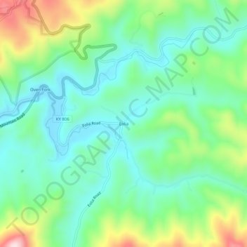
Name: Eolia topographic map, elevation, terrain.
Location: Eolia, Letcher County, Kentucky, 40826, United States (37.03371 -82.81155 37.07371 -82.77155)
Average elevation: 2,008 ft
Minimum elevation: 1,627 ft
Maximum elevation: 2,933 ft
Other topographic maps
Click on a map to view its topography, its elevation and its terrain.
Jenkins
United States > Kentucky > Letcher County
Jenkins, Letcher County, Kentucky, 41517, United States
Average elevation: 1,936 ft
Fleming-Neon
United States > Kentucky > Letcher County
Fleming-Neon, Letcher County, Kentucky, United States
Average elevation: 1,604 ft
Roxana
United States > Kentucky > Letcher County
Roxana, Letcher County, Kentucky, 41832, United States
Average elevation: 1,394 ft
Gordon
United States > Kentucky > Letcher County
Gordon, Letcher County, Kentucky, 40823, United States
Average elevation: 1,926 ft
Whitesburg
United States > Kentucky > Letcher County
Whitesburg, Letcher County, Kentucky, United States
Average elevation: 1,463 ft
Dunham
United States > Kentucky > Letcher County > Jenkins
Dunham, Jenkins, Letcher County, Kentucky, 41835, United States
Average elevation: 1,847 ft
McRoberts
United States > Kentucky > Letcher County
McRoberts, Letcher County, Kentucky, 41835, United States
Average elevation: 1,877 ft
Neon
United States > Kentucky > Letcher County > Fleming-Neon > Neon
Neon, Fleming-Neon, Letcher County, Kentucky, 41840, United States
Average elevation: 1,594 ft
Ermine
United States > Kentucky > Letcher County > Ermine
Ermine, Letcher County, Kentucky, 41837, United States
Average elevation: 1,467 ft