Geolocate

Troja topographic map

Interactive map

Click on the map to display elevation.

About this map

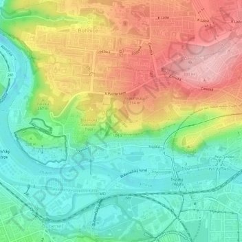
Name: Troja topographic map, elevation, terrain.

Location: Troja, Prague, okres Hlavní město Praha, Hlavní město Praha, Prague, 17100, Czechia (50.11166 14.39495 50.13034 14.44958)

Average elevation: 778 ft

Minimum elevation: 551 ft

Maximum elevation: 1,093 ft

Other topographic maps

Click on a map to view its topography, its elevation and its terrain.

Jewish quarter

Czechia > Prague > Prague

Jewish quarter, Praha 1, Prague, Czechia

Average elevation: 709 ft

Mahlerovy sady

Czechia > Prague > Prague

Mahlerovy sady, Žižkov, Prague, Czechia

Average elevation: 787 ft

Slivenec

Czechia > Prague > Prague

Slivenec, Prague, 154 00, Czechia

Average elevation: 1,070 ft

Prague

Czechia > Prague > Prague

Prague, Czechia

Average elevation: 984 ft

Praha 1

Czechia > Prague > Prague

Praha 1, Prague, Czechia

Average elevation: 751 ft

New Town

Czechia > Prague > Prague

New Town, Prague, Czechia

Average elevation: 705 ft

Old Town

Czechia > Prague > Prague

Old Town, Prague, okres Hlavní město Praha, Hlavní město Praha, Prague, Czechia

Average elevation: 709 ft

Černý Most

Czechia > Prague > Prague

Černý Most, Prague, okres Hlavní město Praha, Hlavní město Praha, Prague, Czechia

Average elevation: 827 ft