
Agatsuma District topographic map
Interactive map
Click on the map to display elevation.
About this map
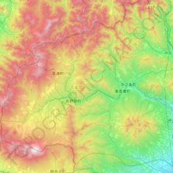
Name: Agatsuma District topographic map, elevation, terrain.
Location: Agatsuma District, Gunma Prefecture, Kanto, Japan (36.40093 138.39702 36.76417 138.99524)
Average elevation: 3,415 ft
Minimum elevation: 315 ft
Maximum elevation: 8,369 ft
Other topographic maps
Click on a map to view its topography, its elevation and its terrain.
Osawa
Japan > Gunma Prefecture > Katashina
Osawa, Katashina, Tone District, Gunma Prefecture, Kanto, Japan
Average elevation: 3,635 ft
Ora District
Oizumi, Ora District, Gunma Prefecture, Kanto, Japan
Average elevation: 105 ft