
Mickleton topographic map
Interactive map
Click on the map to display elevation.
About this map
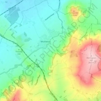
Name: Mickleton topographic map, elevation, terrain.
Average elevation: 390 ft
Minimum elevation: 154 ft
Maximum elevation: 860 ft
Other topographic maps
Click on a map to view its topography, its elevation and its terrain.
The Lake
United Kingdom > England > Cotswold
The Lake, B4068, Upper Slaughter, Cotswold, Gloucestershire, South West England, England, GL54 2JP, United Kingdom
Average elevation: 650 ft
Cotswold
United Kingdom > England > Cotswold
Cotswold, Gloucestershire, South West England, England, United Kingdom
Average elevation: 387 ft
Jamies Wood
United Kingdom > England > Cotswold
Jamies Wood, Fosse Way, Donnington, Cotswold, Gloucestershire, South West England, England, GL56 9AA, United Kingdom
Average elevation: 453 ft