
Zhangjiakou topographic map
Interactive map
Click on the map to display elevation.
About this map
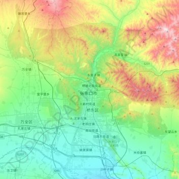
Name: Zhangjiakou topographic map, elevation, terrain.
Average elevation: 3,146 ft
Minimum elevation: 2,077 ft
Maximum elevation: 5,787 ft
Lying in between the Mongolian Plateau and the North China Plain, Zhangjiakou has a somewhat rugged topography characterized by high mountains, deep valleys, and rocky pathways. As a result, it serves as a perfect natural screen for Beijing, which has made it a strategic priority militarily since ancient times. It is called "The Gateway to Beijing" and "The Mountain City beyond the Great Wall". The grand Yan Mountain, the towering Taihang Mountain, the vast grasslands, and the meandering Sangyang River converge here. The city government has regarded tourism as a major driving force of the city's economy and continues to develop the industry.
Other topographic maps
Click on a map to view its topography, its elevation and its terrain.
Chongli District
China > Hebei > Zhangjiakou
Chongli District, Zhangjiakou, Hebei, 076300, China
Average elevation: 4,751 ft
Huailai County
China > Hebei > Zhangjiakou
Huailai County, Zhangjiakou, Hebei, China
Average elevation: 2,756 ft