
Neryungri topographic map
Interactive map
Click on the map to display elevation.
About this map
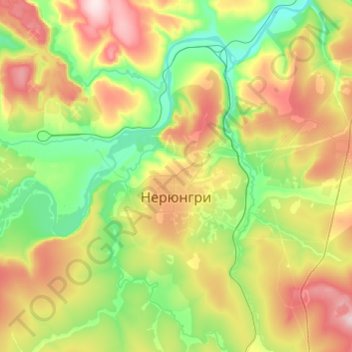
Name: Neryungri topographic map, elevation, terrain.
Average elevation: 2,638 ft
Minimum elevation: 2,211 ft
Maximum elevation: 3,287 ft
Neryungri has a subarctic climate (Köppen climate classification Dfc) with mild summers and severe winters. Precipitation is moderate, but is significantly higher in the summer than at other times of the year. The climate is extremely cold for the latitude in part due to the Siberian High bringing extremely cold polar air to the city in winters, whereas the relatively high elevation and proximity to the cold Sea of Okhotsk usually prevents the heat waves seen in lower areas of Sakha.