
Runcorn topographic map
Interactive map
Click on the map to display elevation.
About this map
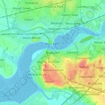
Name: Runcorn topographic map, elevation, terrain.
Average elevation: 72 ft
Minimum elevation: 0 ft
Maximum elevation: 312 ft
Other topographic maps
Click on a map to view its topography, its elevation and its terrain.
Weston
United Kingdom > England > Halton > Runcorn
Weston, Runcorn, Halton, Liverpool City Region, England, WA7 4RB, United Kingdom
Average elevation: 89 ft
Widnes
United Kingdom > England > Halton > Widnes
Widnes, Halton, North West England, England, WA8 6BT, United Kingdom
Average elevation: 79 ft