
Crandon topographic map
Interactive map
Click on the map to display elevation.
About this map
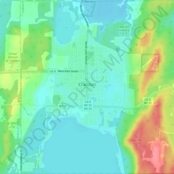
Name: Crandon topographic map, elevation, terrain.
Location: Crandon, Forest County, Wisconsin, United States (45.55064 -88.92314 45.58681 -88.87125)
Average elevation: 1,670 ft
Minimum elevation: 1,588 ft
Maximum elevation: 1,860 ft
Other topographic maps
Click on a map to view its topography, its elevation and its terrain.
Armstrong Creek
United States > Wisconsin > Forest County
Armstrong Creek, Town of Armstrong Creek, Forest County, Wisconsin, 54103, United States
Average elevation: 1,467 ft
Argonne
United States > Wisconsin > Forest County
Argonne, Town of Argonne, Forest County, Wisconsin, 54511, United States
Average elevation: 1,631 ft
Hiles
United States > Wisconsin > Forest County
Hiles, Town of Hiles, Forest County, Wisconsin, United States
Average elevation: 1,680 ft
Town of Freedom
United States > Wisconsin > Forest County
Town of Freedom, Forest County, Wisconsin, 54566, United States
Average elevation: 1,601 ft
Wabeno
United States > Wisconsin > Forest County > Wabeno
Wabeno, Town of Wabeno, Forest County, Wisconsin, 54566, United States
Average elevation: 1,591 ft