
Zahle topographic map
Interactive map
Click on the map to display elevation.
About this map
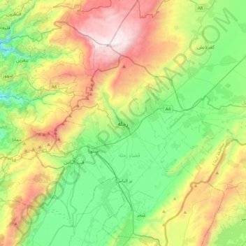
Name: Zahle topographic map, elevation, terrain.
Location: Zahle, Zahlé District, Beqaa Governorate, 1801, Lebanon (33.68765 35.74263 34.00765 36.06263)
Average elevation: 4,203 ft
Minimum elevation: 1,844 ft
Maximum elevation: 8,563 ft
Zahlé is located 55 km (34 mi) east of the capital Beirut, close to the Beirut-Damascus road, and lies at the junction of the Lebanon mountains and the Beqaa plateau, at a mean elevation of 1,000 m. Zahlé is known as the "Bride of the Beqaa" and "the Neighbor of the Gorge" for its geographical location and attractiveness, but also as "the City of Wine and Poetry". Zahle is called "Dar el Salam" which means home of peace. It is famous throughout Lebanon and the region for its pleasant climate, numerous riverside restaurants and quality arak. Its inhabitants are predominantly Melkite Greek Catholic and are known in Arabic as Zahlawi.
Other topographic maps
Click on a map to view its topography, its elevation and its terrain.
Mrayjat
Mrayjat, Zahlé District, Beqaa Governorate, 1802, Lebanon
Average elevation: 3,750 ft
Kfar Mishki
Kfar Mishki, Rashayya District, Beqaa Governorate, Lebanon
Average elevation: 3,422 ft
Anjar
Anjar, Zahlé District, Beqaa Governorate, Lebanon
Average elevation: 3,107 ft
Saghbine
Saghbine, Western Beqaa District, Beqaa Governorate, Lebanon
Average elevation: 3,658 ft
Mashghara
Mashghara, Western Beqaa District, Beqaa Governorate, Lebanon
Average elevation: 3,596 ft
Western Beqaa District
Western Beqaa District, Beqaa Governorate, Lebanon
Average elevation: 3,579 ft
Rashaya
Lebanon > Beqaa Governorate > Rashaya
Rashaya, Rashayya District, Beqaa Governorate, Lebanon
Average elevation: 3,855 ft
Tall Znoub
Lebanon > Beqaa Governorate > Tall Znoub
Tall Znoub, Western Beqaa District, Beqaa Governorate, Lebanon
Average elevation: 2,884 ft
Fourzol
Lebanon > Beqaa Governorate > Fourzol
Fourzol, Zahlé District, Beqaa Governorate, Lebanon
Average elevation: 3,524 ft
Shouf Cedar Biosphere Reserve Limit
Shouf Cedar Biosphere Reserve Limit, Western Beqaa District, Beqaa Governorate, Lebanon
Average elevation: 3,215 ft