
Crosstown topographic map
Interactive map
Click on the map to display elevation.
About this map
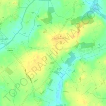
Name: Crosstown topographic map, elevation, terrain.
Average elevation: 56 ft
Minimum elevation: 10 ft
Maximum elevation: 98 ft
Other topographic maps
Click on a map to view its topography, its elevation and its terrain.
Curracloe
Curracloe, The Borough District of Wexford, County Wexford, Leinster, Y21 DP62, Ireland
Average elevation: 69 ft
Bing
Bing, St. Helen's ED, The Borough District of Wexford, County Wexford, Leinster, Ireland
Average elevation: 20 ft
Rosslare
Rosslare, The Borough District of Wexford, County Wexford, Leinster, Ireland
Average elevation: 13 ft
Lady's Island
Lady's Island, The Borough District of Wexford, County Wexford, Leinster, Y35 E2P3, Ireland
Average elevation: 43 ft
St. John's
St. John's, Enniscorthy Rural ED, The Municipal District of Enniscorthy, County Wexford, Leinster, Ireland
Average elevation: 108 ft
Ballyconnigar Upper
Ballyconnigar Upper, Castle Talbot ED, The Municipal District of Gorey — Kilmuckridge, County Wexford, Leinster, Ireland
Average elevation: 79 ft
Enniscorthy
Enniscorthy, Bellefield, Enniscorthy Rural ED, The Municipal District of Enniscorthy, County Wexford, Leinster, Ireland
Average elevation: 102 ft
Landscape
Landscape, Oldcourt ED, The Municipal District of New Ross, County Wexford, Leinster, Ireland
Average elevation: 151 ft
Corbally
Corbally, Ford ED, The Municipal District of Gorey — Kilmuckridge, County Wexford, Leinster, Ireland
Average elevation: 125 ft
Rosslare
Ireland > County Wexford > Rosslare
Rosslare, The Borough District of Wexford, County Wexford, Leinster, Y35 F583, Ireland
Average elevation: 7 ft
The Borough District of Wexford
The Borough District of Wexford, County Wexford, Leinster, Ireland
Average elevation: 95 ft
New Ross
New Ross, County Wexford, Leinster, Ireland
Average elevation: 128 ft
Ballyhack
Ireland > County Wexford > Ballyhack
Ballyhack, The Municipal District of New Ross, County Wexford, Leinster, X91 R252, Ireland
Average elevation: 112 ft