
Kunene Region topographic map
Interactive map
Click on the map to display elevation.
About this map
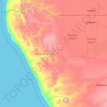
Name: Kunene Region topographic map, elevation, terrain.
Location: Kunene Region, Namibia (-21.19346 11.73672 -16.96351 16.72248)
Average elevation: 2,533 ft
Minimum elevation: -7 ft
Maximum elevation: 7,867 ft
Other topographic maps
Click on a map to view its topography, its elevation and its terrain.
NamibRand Nature Reserve
NamibRand Nature Reserve, Hardap, Namibia
Average elevation: 3,802 ft
Khorixas
Namibia > Kunene Region > Khorixas
Khorixas, Kunene Region, Namibia
Average elevation: 3,196 ft