
Mt. Asama topographic map
Interactive map
Click on the map to display elevation.
About this map
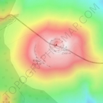
Name: Mt. Asama topographic map, elevation, terrain.
Average elevation: 7,152 ft
Minimum elevation: 5,738 ft
Maximum elevation: 8,409 ft
Other topographic maps
Click on a map to view its topography, its elevation and its terrain.
Karuizawa
Japan > Chubu Region > Karuizawa
Karuizawa, Kitasaku County, Nagano Prefecture, Chubu Region, 389-0102, Japan
Average elevation: 3,340 ft