
Ward 105 Gachibowli topographic map
Interactive map
Click on the map to display elevation.
About this map
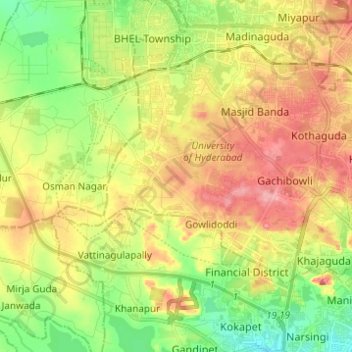
Name: Ward 105 Gachibowli topographic map, elevation, terrain.
Average elevation: 1,864 ft
Minimum elevation: 1,696 ft
Maximum elevation: 2,051 ft
Other topographic maps
Click on a map to view its topography, its elevation and its terrain.
Greater Hyderabad Municipal Corporation South Zone
Greater Hyderabad Municipal Corporation South Zone, Hyderabad, Bahadurpura mandal, Hyderabad, Telangana, India
Average elevation: 1,755 ft
Ward 4 Meerpet H.B Colony
Ward 4 Meerpet H.B Colony, Hyderabad, Uppal mandal, Medchal–Malkajgiri, Telangana, 500040, India
Average elevation: 1,775 ft
Ward 106 Serilingampally
Ward 106 Serilingampally, Greater Hyderabad Municipal Corporation West Zone, Hyderabad, Rangareddy, Telangana, India
Average elevation: 1,929 ft
Ward 7 Chilka Nagar
Ward 7 Chilka Nagar, Greater Hyderabad Municipal Corporation East Zone, Hyderabad, Medchal–Malkajgiri, Telangana, India
Average elevation: 1,634 ft