
Blue Mountain topographic map
Interactive map
Click on the map to display elevation.
About this map
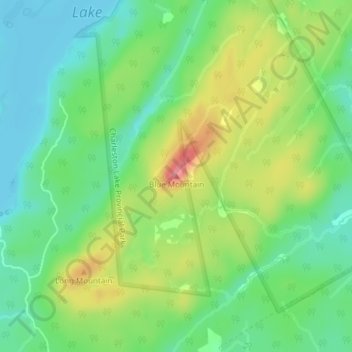
Name: Blue Mountain topographic map, elevation, terrain.
Average elevation: 407 ft
Minimum elevation: 285 ft
Maximum elevation: 614 ft
Other topographic maps
Click on a map to view its topography, its elevation and its terrain.
Lansdowne
Canada > Ontario > Leeds and Grenville Counties > Leeds and the Thousand Islands
Lansdowne, Leeds and the Thousand Islands, Leeds and Grenville Counties, Eastern Ontario, Ontario, K0E 1L0, Canada
Average elevation: 331 ft
Seeleys Bay
Canada > Ontario > Leeds and Grenville Counties > Leeds and the Thousand Islands > Seeley's Bay
Seeleys Bay, Seeley's Bay, Leeds and the Thousand Islands, Leeds and Grenville Counties, Eastern Ontario, Ontario, K0H 2N0, Canada
Average elevation: 344 ft
Leeds
Canada > Ontario > Leeds and Grenville Counties > Leeds and the Thousand Islands
Leeds, Leeds and the Thousand Islands, Leeds and Grenville Counties, Eastern Ontario, Ontario, Canada
Average elevation: 341 ft
Seeley's Bay
Canada > Ontario > Leeds and Grenville Counties > Leeds and the Thousand Islands > Seeley's Bay
Seeley's Bay, Leeds and the Thousand Islands, Leeds and Grenville Counties, Eastern Ontario, Ontario, K0H 2N0, Canada
Average elevation: 348 ft
Waterton
Canada > Ontario > Leeds and Grenville Counties > Leeds and the Thousand Islands > Waterton
Waterton, Leeds and the Thousand Islands, Leeds and Grenville Counties, Eastern Ontario, Ontario, Canada
Average elevation: 318 ft
Lyndhurst
Canada > Ontario > Leeds and Grenville Counties > Leeds and the Thousand Islands
Lyndhurst, Leeds and the Thousand Islands, Leeds and Grenville Counties, Eastern Ontario, Ontario, K0E 1N0, Canada
Average elevation: 322 ft