
Alexandroupoli topographic map
Interactive map
Click on the map to display elevation.
About this map
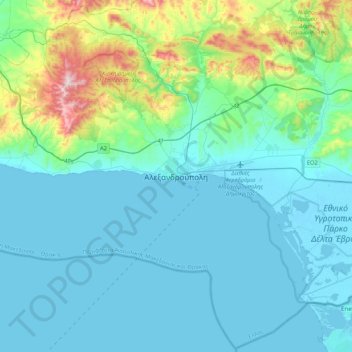
Name: Alexandroupoli topographic map, elevation, terrain.
Average elevation: 312 ft
Minimum elevation: -7 ft
Maximum elevation: 2,054 ft
Other topographic maps
Click on a map to view its topography, its elevation and its terrain.
Samothraki
Greece > Macedonia and Thrace > Evros Regional Unit
Samothraki, Evros Regional Unit, Eastern Macedonia and Thrace, Macedonia and Thrace, 680 02, Greece
Average elevation: 558 ft
Avas
Greece > Macedonia and Thrace > Evros Regional Unit
Avas, Municipality of Alexandroupoli, Evros Regional Unit, Eastern Macedonia and Thrace, Macedonia and Thrace, 681 00, Greece
Average elevation: 535 ft
Kyprinos
Greece > Macedonia and Thrace > Evros Regional Unit > Kyprinos
Kyprinos, Δήμος Ορεστιάδας, Evros Regional Unit, Eastern Macedonia and Thrace, Macedonia and Thrace, 68006, Greece
Average elevation: 223 ft
Orestiada
Greece > Macedonia and Thrace > Evros Regional Unit > Orestiada
Orestiada, Δήμος Ορεστιάδας, Evros Regional Unit, Eastern Macedonia and Thrace, Macedonia and Thrace, 68200, Greece
Average elevation: 135 ft
Νέα Χηλή
Greece > Macedonia and Thrace > Evros Regional Unit
Νέα Χηλή, Municipality of Alexandroupoli, Evros Regional Unit, Eastern Macedonia and Thrace, Macedonia and Thrace, 681 00, Greece
Average elevation: 89 ft