
Fort Oglethorpe topographic map
Interactive map
Click on the map to display elevation.
About this map
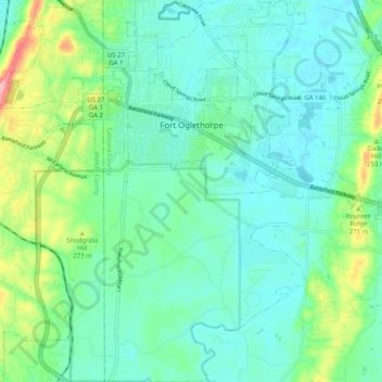
Name: Fort Oglethorpe topographic map, elevation, terrain.
Average elevation: 774 ft
Minimum elevation: 659 ft
Maximum elevation: 1,152 ft
Other topographic maps
Click on a map to view its topography, its elevation and its terrain.
Boynton
United States > Georgia > Catoosa County
Boynton, Catoosa County, Georgia, 30736, United States
Average elevation: 784 ft
Lakeview
United States > Georgia > Catoosa County > Fort Oglethorpe
Lakeview, Fort Oglethorpe, Catoosa County, Georgia, United States
Average elevation: 778 ft
Indian Springs
United States > Georgia > Catoosa County
Indian Springs, Catoosa County, Georgia, United States
Average elevation: 774 ft
Ringgold
United States > Georgia > Catoosa County
Ringgold, Catoosa County, Georgia, United States
Average elevation: 879 ft
Blue Spring
United States > Georgia > Catoosa County
Blue Spring, Catoosa County, Georgia, United States, Blue Spring Lake
Average elevation: 774 ft
Cloud Springs
United States > Georgia > Catoosa County > Fort Oglethorpe
Cloud Springs, Fort Oglethorpe, Catoosa County, Georgia, 30742, United States
Average elevation: 778 ft