
Haarle topographic map
Interactive map
Click on the map to display elevation.
About this map
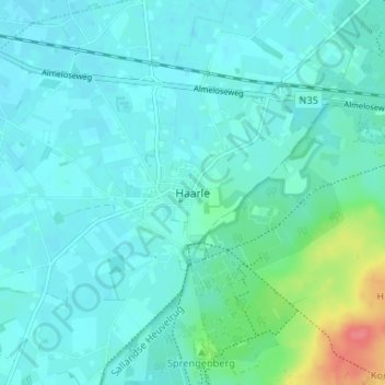
Name: Haarle topographic map, elevation, terrain.
Location: Haarle, Overijssel, Nederland, 7448, Nederland (52.33928 6.36430 52.37928 6.40430)
Average elevation: 56 ft
Minimum elevation: 20 ft
Maximum elevation: 230 ft
Other topographic maps
Click on a map to view its topography, its elevation and its terrain.
Sallandse Heuvelrug
Nederland > Overijssel > Haarle
Sallandse Heuvelrug, Haarle, Hellendoorn, Overijssel, Nederland
Average elevation: 72 ft