
Richland topographic map
Interactive map
Click on the map to display elevation.
About this map
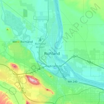
Name: Richland topographic map, elevation, terrain.
Location: Richland, Benton County, Washington, United States (46.19440 -119.40044 46.37063 -119.21148)
Average elevation: 525 ft
Minimum elevation: 305 ft
Maximum elevation: 1,585 ft
According to the United States Census Bureau, the city has a total area of 39.11 square miles (101.29 km2), of which, 35.72 square miles (92.51 km2) is land and 3.39 square miles (8.78 km2) is water. Elevation at the airport is 120 m (394 ft).
Other topographic maps
Click on a map to view its topography, its elevation and its terrain.
Kennewick
United States > Washington > Benton County
Kennewick, Benton County, Washington, United States
Average elevation: 505 ft
Hanford
United States > Washington > Benton County
Hanford, Benton County, Washington, United States
Average elevation: 404 ft
Badger
United States > Washington > Benton County
Badger, Benton County, Washington, United States
Average elevation: 807 ft
Kiona
United States > Washington > Benton County
Kiona, Benton County, Washington, 99320, United States
Average elevation: 735 ft
North Prosser
United States > Washington > Benton County
North Prosser, Benton County, Washington, 99350, United States
Average elevation: 758 ft
Plymouth
United States > Washington > Benton County
Plymouth, Benton County, Washington, 99346, United States
Average elevation: 344 ft
Longview
United States > Washington > Benton County
Longview, Benton County, Washington, United States
Average elevation: 325 ft
Highland
United States > Washington > Benton County
Highland, Benton County, Washington, United States
Average elevation: 643 ft
Whistran Wildlife Area
United States > Washington > Benton County
Whistran Wildlife Area, Benton County, Washington, United States
Average elevation: 764 ft
Finley
United States > Washington > Benton County
Finley, Benton County, Washington, United States
Average elevation: 377 ft
Paterson
United States > Washington > Benton County
Paterson, Benton County, Washington, United States
Average elevation: 410 ft
Benton City
United States > Washington > Benton County
Benton City, Benton County, Washington, United States
Average elevation: 623 ft
West Richland
United States > Washington > Benton County
West Richland, Benton County, Washington, 99353, United States
Average elevation: 479 ft
Kennewick
United States > Washington > Benton County > Kennewick
Kennewick, Benton County, Washington, 99337, United States
Average elevation: 735 ft
Prosser
United States > Washington > Benton County > Prosser > Prosser
Prosser, Benton County, Washington, 99350-1300, United States
Average elevation: 965 ft
Prosser
United States > Washington > Benton County
Prosser, Benton County, Washington, 99350, United States
Average elevation: 919 ft
Audrey
United States > Washington > Benton County
Audrey, Benton County, Washington, United States
Average elevation: 512 ft