
Margate topographic map
Interactive map
Click on the map to display elevation.
About this map
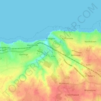
Name: Margate topographic map, elevation, terrain.
Location: Margate, Thanet, Kent, England, United Kingdom (51.36245 1.34033 51.39881 1.43655)
Average elevation: 72 ft
Minimum elevation: 0 ft
Maximum elevation: 180 ft
Other topographic maps
Click on a map to view its topography, its elevation and its terrain.
St Nicholas-at-Wade
United Kingdom > England > Kent > Thanet
St Nicholas-at-Wade, Thanet, Kent, England, United Kingdom
Average elevation: 26 ft
Ramsgate
United Kingdom > England > Kent > Thanet
Ramsgate, Thanet, Kent, England, United Kingdom
Average elevation: 82 ft