
Clydebank topographic map
Interactive map
Click on the map to display elevation.
About this map
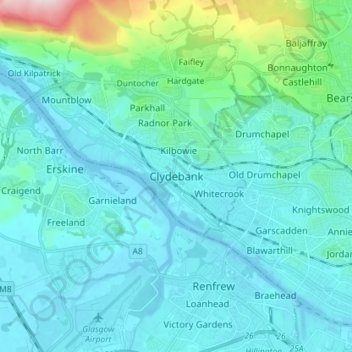
Name: Clydebank topographic map, elevation, terrain.
Average elevation: 144 ft
Minimum elevation: -16 ft
Maximum elevation: 1,122 ft
Other topographic maps
Click on a map to view its topography, its elevation and its terrain.
Faifley
United Kingdom > Scotland > West Dunbartonshire
Faifley, West Dunbartonshire, Scotland, G81 5EB, United Kingdom
Average elevation: 367 ft
Alexandria
United Kingdom > Scotland > West Dunbartonshire
Alexandria, West Dunbartonshire, Scotland, G83 0PB, United Kingdom
Average elevation: 312 ft
Dumbarton
United Kingdom > Scotland > West Dunbartonshire
Dumbarton, West Dunbartonshire, Scotland, G82 1LG, United Kingdom
Average elevation: 246 ft
Cochno Hill
United Kingdom > Scotland > West Dunbartonshire
Cochno Hill, West Dunbartonshire, Scotland, G81 6RW, United Kingdom
Average elevation: 883 ft
Bonhill
United Kingdom > Scotland > West Dunbartonshire
Bonhill, West Dunbartonshire, Scotland, G83 9HS, United Kingdom
Average elevation: 331 ft
Cochno
United Kingdom > Scotland > West Dunbartonshire > Faifley > Cochno
Cochno, Faifley, West Dunbartonshire, Scotland, G81 5QJ, United Kingdom
Average elevation: 584 ft
Gartocharn
United Kingdom > Scotland > West Dunbartonshire
Gartocharn, West Dunbartonshire, Scotland, G83 8RX, United Kingdom
Average elevation: 177 ft
Bowling
United Kingdom > Scotland > West Dunbartonshire
Bowling, West Dunbartonshire, Scotland, G60 5AH, United Kingdom
Average elevation: 344 ft
Tullichewan Muir
United Kingdom > Scotland > West Dunbartonshire > Alexandria > Upper Stoneymollan
Tullichewan Muir, Upper Stoneymollan, Alexandria, West Dunbartonshire, Scotland, G83 8QU, United Kingdom
Average elevation: 554 ft