
South Shields topographic map
Interactive map
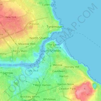
Click on the map to display elevation.
About this map
Name: South Shields topographic map, elevation, terrain.
Average elevation: 75 ft
Minimum elevation: -7 ft
Maximum elevation: 269 ft
The current town was founded in 1245 and developed as a fishing port. The name South Shields developed from the 'Schele' or 'Shield', which was a small dwelling used by fishermen. Another industry that was introduced, was that of salt-panning, later expanded upon in the 15th century, polluting the air and surrounding land. In 1864, a Tyne Commissioners dredger brought up a nine-pounder breech-loading cannon; more cannonballs have been found in the sands beside the Lawe; these artifacts belonged to the English civil war. At the outbreak of the war in 1642, the North, West and Ireland supported the King; the South East and Presbyterian Scotland supported Parliament. In 1644 Parliament's Scottish Covenanter allies, in a lengthy battle, seized the town and its Royalist fortification, the fortification was close to the site of the original Roman fort. They also seized the town of Newburn. These raids were done to aid their ongoing siege of the heavily fortified Newcastle upon Tyne, and in a bid to control the River Tyne, and the North, and the Shields siege helped cause their battalions to maneuver south to York; this may have also led to a brief winter skirmish on the outskirts of Boldon, though the topography is not favourable for a battle.
Other topographic maps
Click on a map to view its topography, its elevation and its terrain.
Jarrow
United Kingdom > England > Tyne and Wear > South Tyneside
Jarrow, South Tyneside, Tyne and Wear, North East, England, NE32 3JU, United Kingdom
Average elevation: 105 ft