
Nis topographic map
Interactive map
Click on the map to display elevation.
About this map
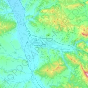
Name: Nis topographic map, elevation, terrain.
Average elevation: 1,198 ft
Minimum elevation: 548 ft
Maximum elevation: 4,951 ft
Other topographic maps
Click on a map to view its topography, its elevation and its terrain.
Gornji Matejevac
Serbia > Central Serbia > Nis
Gornji Matejevac, Nis, Nis City, Nisava Administrative District, Central Serbia, Serbia
Average elevation: 1,467 ft