
Alençon topographic map
Interactive map
Click on the map to display elevation.
About this map
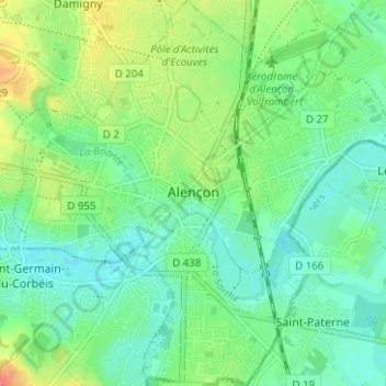
Name: Alençon topographic map, elevation, terrain.
Location: Alençon, Orne, Normandy, Metropolitan France, 61000, France (48.41031 0.06183 48.45183 0.12276)
Average elevation: 466 ft
Minimum elevation: 417 ft
Maximum elevation: 558 ft
Other topographic maps
Click on a map to view its topography, its elevation and its terrain.
Neuvy-au-Houlme
Neuvy-au-Houlme, Argentan, Orne, Normandy, Metropolitan France, 61210, France
Average elevation: 630 ft
Domfront en Poiraie
Domfront en Poiraie, Argentan, Orne, Normandy, Metropolitan France, 61700, France
Average elevation: 571 ft
Vimoutiers
Vimoutiers, Mortagne-au-Perche, Orne, Normandy, Metropolitan France, 61120, France
Average elevation: 564 ft
Chambois
France > Normandy > Orne > Gouffern en Auge
Chambois, Gouffern en Auge, Argentan, Orne, Normandy, Metropolitan France, 61160, France
Average elevation: 377 ft
Les Champeaux
Les Champeaux, Mortagne-au-Perche, Orne, Normandy, Metropolitan France, 61120, France
Average elevation: 689 ft
Les Courtils
France > Normandy > Orne > Putanges-le-Lac > Putanges-Pont-Écrepin
Les Courtils, Putanges-Pont-Écrepin, Putanges-le-Lac, Argentan, Orne, Normandy, Metropolitan France, 61210, France
Average elevation: 610 ft
La Ferté-Macé
France > Normandy > Orne > La Ferté-Macé
La Ferté-Macé, Argentan, Orne, Normandy, Metropolitan France, 61600, France
Average elevation: 709 ft
La Rouge
France > Normandy > Orne > Val-au-Perche
La Rouge, Val-au-Perche, Mortagne-au-Perche, Orne, Normandy, Metropolitan France, 61260, France
Average elevation: 417 ft