
Cork topographic map
Interactive map
Click on the map to display elevation.
About this map
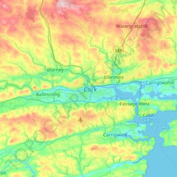
Name: Cork topographic map, elevation, terrain.
Location: Cork, Cork City 2019, County Cork, Munster, T12 EE6N, Ireland (51.73793 -8.63058 52.05793 -8.31058)
Average elevation: 308 ft
Minimum elevation: -10 ft
Maximum elevation: 997 ft
Other topographic maps
Click on a map to view its topography, its elevation and its terrain.
Ballincollig
Ireland > Cork > Ballincollig
Ballincollig, Cork, County Cork, Munster, P31 V085, Ireland
Average elevation: 203 ft
Greenmount
Greenmount, Cork, Cork City 2019, County Cork, Munster, Ireland
Average elevation: 62 ft