
Central Point topographic map
Interactive map
Click on the map to display elevation.
About this map
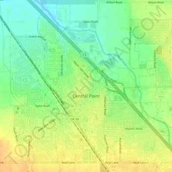
Name: Central Point topographic map, elevation, terrain.
Average elevation: 1,263 ft
Minimum elevation: 1,207 ft
Maximum elevation: 1,316 ft
The city lies at an elevation of about 1,272 feet (388 m) along Oregon Highway 99 and Interstate 5 northwest of Medford. Jacksonville is to the south and Gold Hill to the northwest. The Central Oregon and Pacific Railroad passes through Central Point.
Other topographic maps
Click on a map to view its topography, its elevation and its terrain.
Ashland
United States > Oregon > Jackson County
Ashland, Jackson County, Oregon, United States
Average elevation: 2,539 ft
Trail
United States > Oregon > Jackson County
Trail, Jackson County, Oregon, 97539, United States
Average elevation: 1,752 ft
Ruch
United States > Oregon > Jackson County
Ruch, Jackson County, Oregon, United States
Average elevation: 1,837 ft
Applegate
United States > Oregon > Jackson County
Applegate, Jackson County, Oregon, United States
Average elevation: 1,644 ft
Medford
United States > Oregon > Jackson County
Medford, Jackson County, Oregon, United States
Average elevation: 1,447 ft
White City
United States > Oregon > Jackson County
White City, Jackson County, Oregon, 97503, United States
Average elevation: 1,325 ft
Siskiyou Gap
United States > Oregon > Jackson County
Siskiyou Gap, Jackson County, Oregon, United States
Average elevation: 5,728 ft
Fish Lake
United States > Oregon > Jackson County
Fish Lake, Jackson County, Oregon, United States
Average elevation: 4,777 ft
Shady Cove
United States > Oregon > Jackson County
Shady Cove, Jackson County, Oregon, 97539, United States
Average elevation: 1,660 ft
Eagle Point
United States > Oregon > Jackson County
Eagle Point, Jackson County, Oregon, 97524, United States
Average elevation: 1,385 ft
Lost Creek Lake
United States > Oregon > Jackson County
Lost Creek Lake, Jackson County, Oregon, United States
Average elevation: 2,392 ft
Buncom
United States > Oregon > Jackson County
Buncom, Jackson County, Oregon, United States
Average elevation: 2,146 ft
Mount Ashland
United States > Oregon > Jackson County
Mount Ashland, Jackson County, Oregon, United States
Average elevation: 6,421 ft
Rogue River
United States > Oregon > Jackson County
Rogue River, Jackson County, Oregon, 97537, United States
Average elevation: 1,188 ft
Phoenix
United States > Oregon > Jackson County
Phoenix, Jackson County, Oregon, 97535, United States
Average elevation: 1,539 ft
Wagner Butte
United States > Oregon > Jackson County
Wagner Butte, Jackson County, Oregon, United States
Average elevation: 6,063 ft
Gold Hill
United States > Oregon > Jackson County
Gold Hill, Jackson County, Oregon, United States
Average elevation: 1,365 ft
Talent
United States > Oregon > Jackson County
Talent, Jackson County, Oregon, United States
Average elevation: 1,693 ft
Jacksonville
United States > Oregon > Jackson County
Jacksonville, Jackson County, Oregon, 97530, United States
Average elevation: 1,713 ft