
Trieste topographic map
Interactive map
Click on the map to display elevation.
About this map
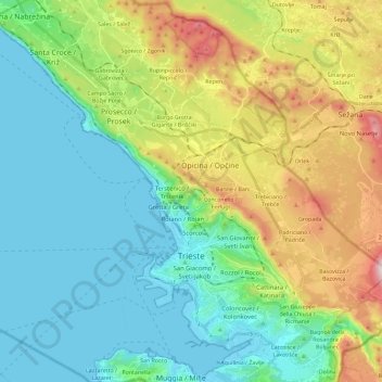
Name: Trieste topographic map, elevation, terrain.
Location: Trieste, Friuli-Venezia Giulia, 34121-34151, Italy (45.60680 13.66832 45.74662 13.89831)
Average elevation: 604 ft
Minimum elevation: -3 ft
Maximum elevation: 2,123 ft
Trieste lies in the northernmost part of the high Adriatic in northeastern Italy, near the border with Slovenia. The city lies on the Gulf of Trieste. Built mostly on a hillside that becomes a mountain, Trieste's urban territory lies at the foot of an imposing escarpment that comes down abruptly from the Karst Plateau towards the sea. The karst hills delimiting the city reach an elevation of 458 metres (1,503 feet) above sea level. It lies at the junction point of the Italian geographical region, the Balkan Peninsula, and Mitteleuropan Area.
Other topographic maps
Click on a map to view its topography, its elevation and its terrain.
Bagnoli della Rosandra / Boljunec
Italy > Friuli-Venezia Giulia > Trieste > San Dorligo della Valle / Dolina
Bagnoli della Rosandra / Boljunec, San Dorligo della Valle / Dolina, Trieste, Friuli-Venezia Giulia, 34018, Italy
Average elevation: 735 ft
Grotta a S del Monte Gurca
Italy > Friuli-Venezia Giulia > Trieste > Trieste > Opicina / Opčine
Grotta a S del Monte Gurca, Via Ulderico Moro, Barcola / Barkovlje, Roiano-Gretta-Barcola-Cologna-Scorcola, Opicina / Opčine, Trieste, Friuli-Venezia Giulia, 34136, Italy
Average elevation: 584 ft
Conconello / Ferlugi
Italy > Friuli-Venezia Giulia > Trieste > Trieste
Conconello / Ferlugi, Trieste, Friuli-Venezia Giulia, 34127, Italy
Average elevation: 801 ft