
Tashkent topographic map
Interactive map
Click on the map to display elevation.
About this map
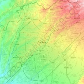
Name: Tashkent topographic map, elevation, terrain.
Location: Tashkent, 100128, Uzbekistan (41.15234 69.11871 41.47234 69.43871)
Average elevation: 1,467 ft
Minimum elevation: 1,155 ft
Maximum elevation: 2,064 ft
Other topographic maps
Click on a map to view its topography, its elevation and its terrain.
Yakkasaray district
Yakkasaray district, Tashkent, 100000, Uzbekistan
Average elevation: 1,430 ft
Mirzo Ulugbek district
Mirzo Ulugbek district, Tashkent, 100000, Uzbekistan
Average elevation: 1,575 ft
Tashkent
Chilanzar District, Yakkasaroy Tumani, Tashkent, 100000, Uzbekistan
Average elevation: 1,391 ft