
Qingdao topographic map
Interactive map
Click on the map to display elevation.
About this map
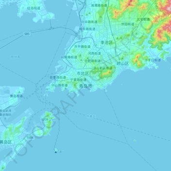
Name: Qingdao topographic map, elevation, terrain.
Average elevation: 82 ft
Minimum elevation: -20 ft
Maximum elevation: 2,300 ft
Qingdao is located on the south facing coast of the Shandong Peninsula (German: Schantung Halbinsel). It borders three prefecture-level cities, namely Yantai to the northeast, Weifang to the west, and Rizhao to the southwest. The city's total jurisdiction area occupies 10,654 square kilometres (4,114 sq mi), and stretches in latitude from 35° 35' to 37° 09' N and in longitude from 119° 30' to 121° 00' E. The populated sections of the city are relatively flat while mountains spur up within city limits and nearby. The highest elevation in the city is 1,133 metres (3,717 ft) above sea level. Of the total area of Qingdao, 15.5% is highland, while the foothill, plain and lowland areas constitute 25.1%, 37.8% and 21.7%. The city has a 730.64 kilometres (454.00 mi) coastline. Five significant rivers that flow for more than 50 kilometres (31 mi) can be found in the region.