
Växjö topographic map
Interactive map
Click on the map to display elevation.
About this map
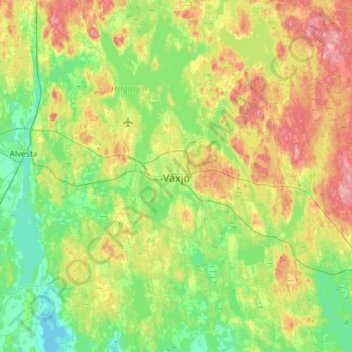
Name: Växjö topographic map, elevation, terrain.
Location: Växjö, Växjö kommun, Kronoberg County, 351 04, Sweden (56.71872 14.64944 57.03872 14.96944)
Average elevation: 571 ft
Minimum elevation: 446 ft
Maximum elevation: 820 ft
Other topographic maps
Click on a map to view its topography, its elevation and its terrain.
Värpeshult
Värpeshult, Älmhults kommun, Kronoberg County, 343 72, Sweden
Average elevation: 581 ft
Södra Århult
Sweden > Kronoberg County > Markaryd
Södra Århult, Markaryd, Markaryds kommun, Kronoberg County, 285 35, Sweden
Average elevation: 364 ft
Vittaryd
Vittaryd, Ljungby kommun, Kronoberg County, 341 52, Sweden
Average elevation: 528 ft