
Temoaya topographic map
Interactive map
Click on the map to display elevation.
About this map
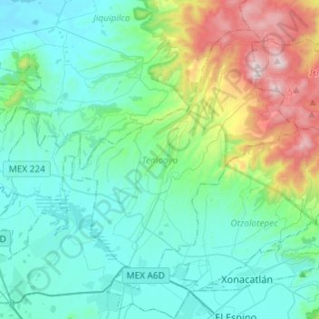
Name: Temoaya topographic map, elevation, terrain.
Location: Temoaya, Mexico, 50850, Mexico (19.39625 -99.73111 19.58238 -99.48927)
Average elevation: 9,154 ft
Minimum elevation: 8,310 ft
Maximum elevation: 12,359 ft
The climate is temperate and relatively humid with rains mostly in the summer. Average temperature is 13.4C, ranging between 9 and 35.5C. It is one of the coldest municipalities in the Toluca Valley due to its altitude. Frosts can occur between October and April and morning fog is not uncommon the rest of the year. In the higher elevations there are forest with pine, cedar, oyamel and other trees. In the lower areas there are some broadleaf trees but there are more areas with grass and shrub. Most of the flat areas are cultivated with both field crops and orchards. Very little wildlife remains due to the degradation of most of the ecosystem here. Some small mammals such as squirrels, rabbits and the like remain as well as some bird species. Aquatic life has completely disappeared from the Lerma River area.
Other topographic maps
Click on a map to view its topography, its elevation and its terrain.
Tejupilco de Hidalgo
Mexico > Mexico > Tejupilco de Hidalgo
Tejupilco de Hidalgo, Tejupilco, Mexico, 51400, Mexico
Average elevation: 4,925 ft
Chimalhuacán
Mexico > Mexico > Chimalhuacán
Chimalhuacán, Mexico, 56334, Mexico
Average elevation: 7,559 ft
San Pablo de las Salinas
Mexico > Mexico > San Pablo de las Salinas
San Pablo de las Salinas, Tultitlán, Mexico, 549131, Mexico
Average elevation: 7,365 ft
San Buenaventura
Mexico > Mexico > San Buenaventura
San Buenaventura, Ixtapaluca, Mexico, 56643, Mexico
Average elevation: 7,497 ft
Santa Cruz Atizapán.
Mexico > Mexico > Santa Cruz Atizapán.
Santa Cruz Atizapán., Atizapán, Mexico, 52640, Mexico
Average elevation: 8,537 ft
Presa Brockman
Mexico > Mexico > Presa Brockman
Presa Brockman, El Oro, Mexico
Average elevation: 9,669 ft
El Oro de Hidalgo
Mexico > Mexico > El Oro de Hidalgo
El Oro de Hidalgo, El Oro, Mexico
Average elevation: 9,216 ft
Nevado de Toluca
Nevado de Toluca, Toluca, Mexico
Average elevation: 13,878 ft