
Durango topographic map
Interactive map
Click on the map to display elevation.
About this map
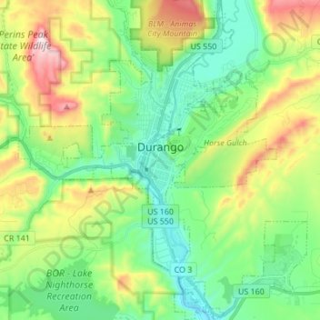
Name: Durango topographic map, elevation, terrain.
Location: Durango, La Plata County, Colorado, United States (37.21896 -107.91812 37.29905 -107.81391)
Average elevation: 7,057 ft
Minimum elevation: 6,355 ft
Maximum elevation: 8,094 ft
Durango is located at 37°16′N 107°52′W / 37.267°N 107.867°W / 37.267; -107.867 at an elevation of 6,512 ft (1,988 m). At the 2020 United States Census, the town had a total area of 10,946 acres (44.296 km2) including 1,533 acres (6.203 km2) of water.
Other topographic maps
Click on a map to view its topography, its elevation and its terrain.
Ignacio
United States > Colorado > La Plata County
Ignacio, La Plata County, Colorado, 81137, United States
Average elevation: 6,509 ft
Durango
United States > Colorado > La Plata County
Durango, La Plata County, Colorado, United States
Average elevation: 7,093 ft
Needle Mountains Peak Sixteen
United States > Colorado > La Plata County
Needle Mountains Peak Sixteen, La Plata County, Colorado, United States
Average elevation: 12,503 ft
Cherry Creek
United States > Colorado > La Plata County
Cherry Creek, La Plata County, Colorado, United States
Average elevation: 7,234 ft
Texas Creek
United States > Colorado > La Plata County > Columbus
Texas Creek, Columbus, La Plata County, Colorado, United States
Average elevation: 7,543 ft
Twin Buttes
United States > Colorado > La Plata County > Durango
Twin Buttes, Durango, La Plata County, Colorado, 81302, United States
Average elevation: 7,247 ft
Missionary Ridge
United States > Colorado > La Plata County
Missionary Ridge, La Plata County, Colorado, United States
Average elevation: 9,846 ft
Lake of the Pines
United States > Colorado > La Plata County
Lake of the Pines, La Plata County, Colorado, United States
Average elevation: 9,137 ft
Cherry Creek
United States > Colorado > La Plata County
Cherry Creek, La Plata County, Colorado, United States
Average elevation: 7,963 ft
Redmesa
United States > Colorado > La Plata County
Redmesa, La Plata County, Colorado, 81329, United States
Average elevation: 6,519 ft
Durango
United States > Colorado > La Plata County > Durango
Durango, La Plata County, Colorado, 81302, United States
Average elevation: 7,743 ft
Grimes Creek
United States > Colorado > La Plata County
Grimes Creek, La Plata County, Colorado, United States
Average elevation: 8,917 ft
Bayfield
United States > Colorado > La Plata County
Bayfield, La Plata County, Colorado, United States
Average elevation: 6,988 ft
Hesperus
United States > Colorado > La Plata County
Hesperus, La Plata County, Colorado, 81326, United States
Average elevation: 8,281 ft
Mount Eolus
United States > Colorado > La Plata County
Mount Eolus, La Plata County, Colorado, United States
Average elevation: 12,497 ft
Cumberland Mountain
United States > Colorado > La Plata County
Cumberland Mountain, La Plata County, Colorado, United States
Average elevation: 11,227 ft