
Corinth topographic map
Interactive map
Click on the map to display elevation.
About this map
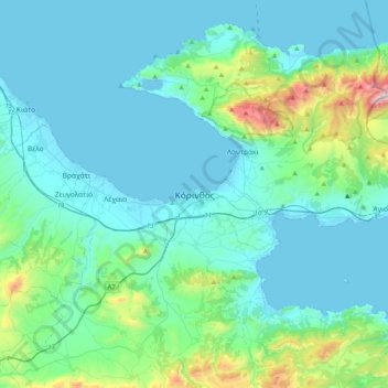
Name: Corinth topographic map, elevation, terrain.
Average elevation: 607 ft
Minimum elevation: -10 ft
Maximum elevation: 4,449 ft
Other topographic maps
Click on a map to view its topography, its elevation and its terrain.
Municipal Unit of Evrostina
Greece > Peloponnese, Western Greece and the Ionian > Corinthia Regional Unit
Municipal Unit of Evrostina, Municipality of Xylokastro and Evrostina, Corinthia Regional Unit, Peloponnese Region, Peloponnese, Western Greece and the Ionian, Greece
Average elevation: 2,293 ft
Σούλι
Greece > Peloponnese, Western Greece and the Ionian > Corinthia Regional Unit > Municipal Unit of Sikyona
Σούλι, Municipal Unit of Sikyona, Municipality of Sikyona, Corinthia Regional Unit, Peloponnese Region, Peloponnese, Western Greece and the Ionian, 200 15, Greece
Average elevation: 1,959 ft
Municipal Unit of Corinth
Greece > Peloponnese, Western Greece and the Ionian > Corinthia Regional Unit
Municipal Unit of Corinth, Municipality of Corinth, Corinthia Regional Unit, Peloponnese Region, Peloponnese, Western Greece and the Ionian, Greece
Average elevation: 413 ft
Kyllini (Ziria)
Greece > Peloponnese, Western Greece and the Ionian > Corinthia Regional Unit > Municipal Unit of Xylokastro
Kyllini (Ziria), Municipal Unit of Xylokastro, Municipality of Xylokastro and Evrostina, Corinthia Regional Unit, Peloponnese Region, Peloponnese, Western Greece and the Ionian, Greece
Average elevation: 6,542 ft
Corinth Canal
Greece > Peloponnese, Western Greece and the Ionian > Corinthia Regional Unit > Municipal Unit of Loutraki - Perachora > Γαλότα
Corinth Canal, Γαλότα, Community of Loutraki - Perachora, Municipal Unit of Loutraki - Perachora, Loutraki-Perachora-Agioi Theodoroi Municipality, Corinthia Regional Unit, Peloponnese Region, Peloponnese, Western Greece and the Ionian, Greece
Average elevation: 200 ft
Municipal Unit of Velos
Greece > Peloponnese, Western Greece and the Ionian > Corinthia Regional Unit
Municipal Unit of Velos, Municipality of Velo and Vocha, Corinthia Regional Unit, Peloponnese Region, Peloponnese, Western Greece and the Ionian, 200 02, Greece
Average elevation: 906 ft
Community of Ano Trikala
Greece > Peloponnese, Western Greece and the Ionian > Corinthia Regional Unit > Municipal Unit of Xylokastro
Community of Ano Trikala, Municipal Unit of Xylokastro, Municipality of Xylokastro and Evrostina, Corinthia Regional Unit, Peloponnese Region, Peloponnese, Western Greece and the Ionian, Greece
Average elevation: 5,089 ft
Νεμέα
Greece > Peloponnese, Western Greece and the Ionian > Corinthia Regional Unit > Νεμέα
Νεμέα, Municipality of Nemea, Corinthia Regional Unit, Peloponnese Region, Peloponnese, Western Greece and the Ionian, 20500, Greece
Average elevation: 1,316 ft
Kiato
Greece > Peloponnese, Western Greece and the Ionian > Corinthia Regional Unit > Municipal Unit of Sikyona
Kiato, Municipal Unit of Sikyona, Municipality of Sikyona, Corinthia Regional Unit, Peloponnese Region, Peloponnese, Western Greece and the Ionian, 202 00, Greece
Average elevation: 105 ft