
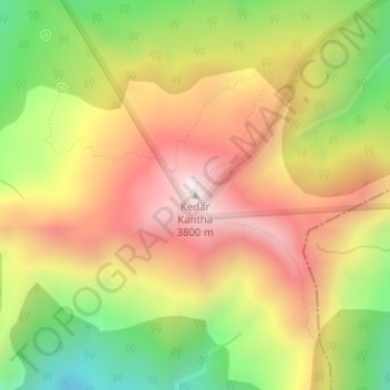
Kedarkantha topographic map
Interactive map
Click on the map to display elevation.
About this map
Name: Kedarkantha topographic map, elevation, terrain.
Location: Kedarkantha, Mori, Uttarkashi, India (31.02248 78.17185 31.02258 78.17195)
Average elevation: 11,168 ft
Minimum elevation: 9,669 ft
Maximum elevation: 12,503 ft
Kedarkantha is a mountain peak of the Himalayas in Uttarakhand, India. Its elevation is 12,500 ft (3,800 m). Kedarkantha is located within Govind Wildlife Sanctuary in Uttarkashi district.
Other topographic maps
Click on a map to view its topography, its elevation and its terrain.