
هرقلة topographic map
Interactive map
Click on the map to display elevation.
About this map
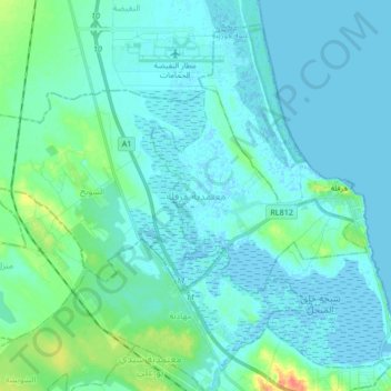
Name: هرقلة topographic map, elevation, terrain.
Location: هرقلة, Sousse, 4012, Tunisia (35.96923 10.36620 36.08855 10.53408)
Average elevation: 20 ft
Minimum elevation: -16 ft
Maximum elevation: 141 ft
Other topographic maps
Click on a map to view its topography, its elevation and its terrain.
Boujafar Beach
Boujafar Beach, بوجعفر, معتمدية سوسة المدينة, Sousse, Tunisia
Average elevation: 30 ft
Sousse
Tunisia > Sousse > محمد معروف
Sousse, محمد معروف, معتمدية سوسة المدينة, Sousse, Tunisia
Average elevation: 43 ft